
~「驚愕秘景」どこここ108景~
1. シリパ岬 2. えびす岩と大黒岩 3. 島武意海岸 4. 滝瀬海岸(シラフラ) 5. 旭浜のトーチカ群 6. ゴロタ岬 7. 苔の回廊 8. 黄金山 9. あんない展望公園 10. 旭岳の展望台群 11. 知床五湖の展望台群 12. 館の岬 13. 日浦海岸/道南金剛 14. 恵山
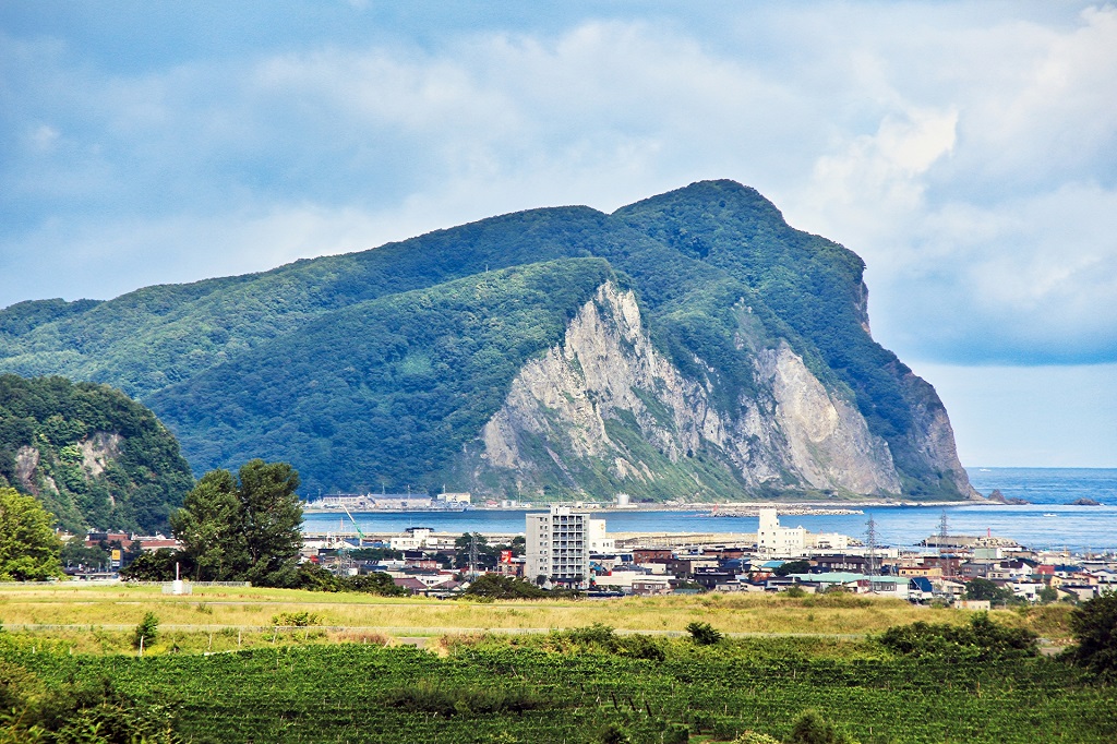
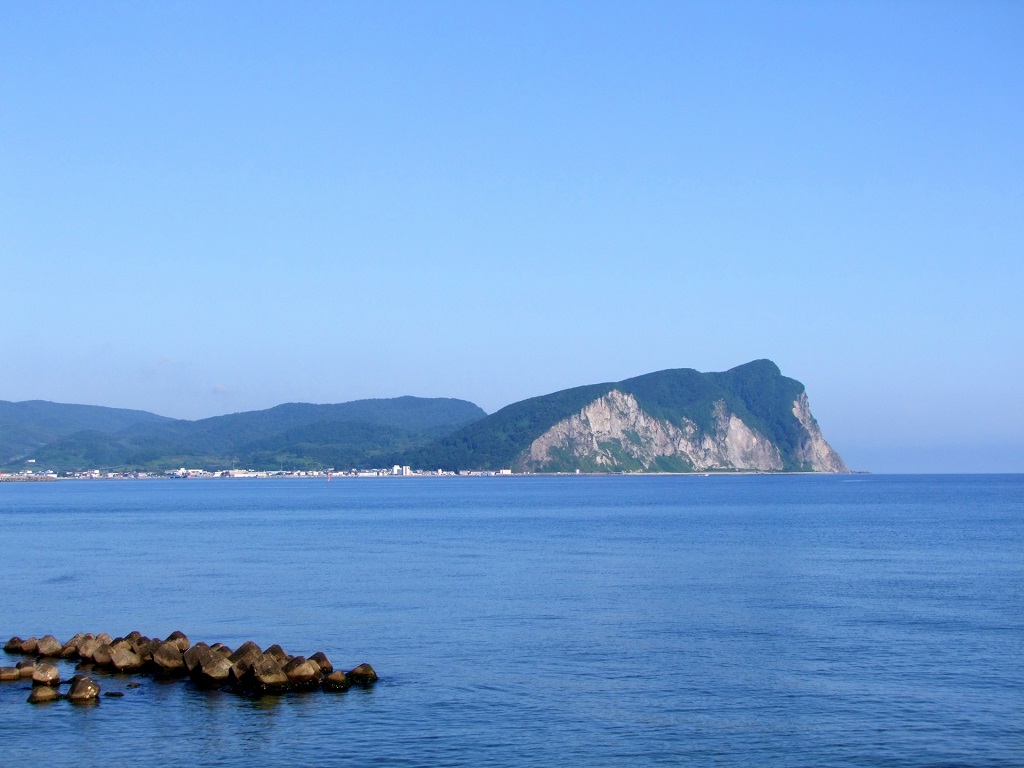
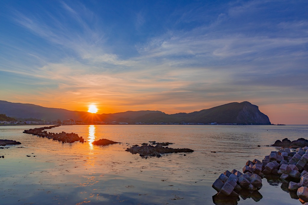
No.1 シリパ岬
積丹半島のふもとにある余市町のシンボルでもありますシリパ岬。上の画像はかなり望遠レンズで引き寄せていますが、実際は下画像のような風景です。
シリパとはアイヌ語で山の頭という意味で、断崖絶壁の崖がまさに驚きの秘景感を醸しだしています。ちなみに、シリパ岬の突端には尻場山という300m弱の山があり絶景が望めますが、往路3km(1時間30分)、復路2km(1時間)もの山道を歩くことになります。
夕陽も絶景です。
no.1 Shiripa cape
SHIRIPA cape that, too, is the symbol of Yoichi-cho that is in a foot in Shakotan-hanto.
An image above is pulled considerably with a telephotographic lens but a fact is the scenery like an image below.
SHIRIPA is a point in a head in a mountain in an Aino, and a cliff in a cliff cliff is creating surprising secret view indeed.
By the way, a tip in a SHIRIPA cape has a little less than 300 m of mountains of bottom Bayama, and a superb view can be wanted but walks in the mountain path of 3 km of first halves ( 30 minutes per 1 hour ), 2 km of homeward journey ( 1 hour ).
The setting sun, too, is a superb view.
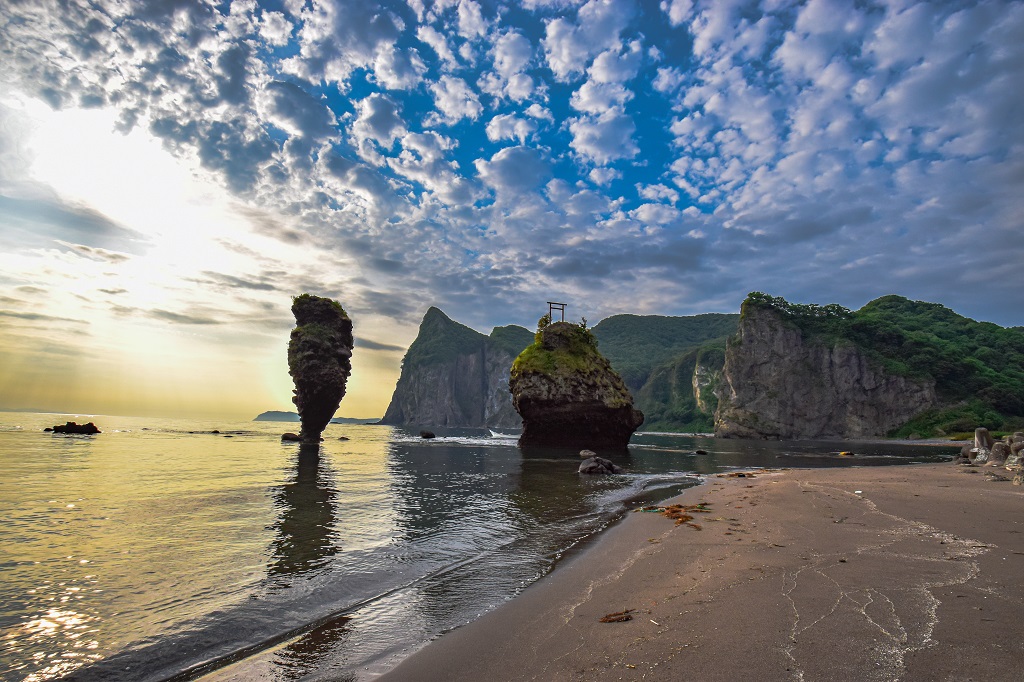
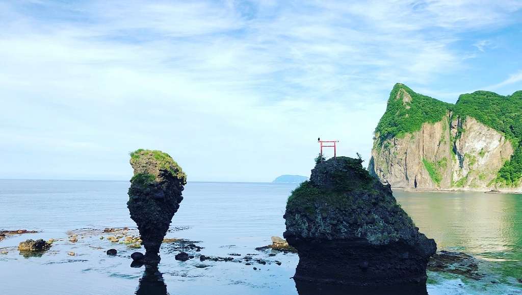
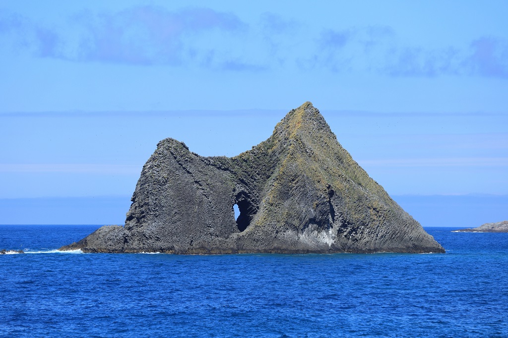
No.2 えびす岩と大黒岩
余市町にあります奇岩奇勝の多い積丹半島を代表する奇岩で、特にえびす岩はよく折れないで立っているな…と驚く景観です。
そして、大黒岩の上には鳥居が建てられています。また、後ろにある烏帽子岩の景観も趣があり、烏帽子岩と大黒岩を引き立てています。
なお、すぐそばの島泊の海岸からは、500m先の海上に立つ45mの高さのローソク岩を望むことができます。
No.2 Ebisuiwa and Daikokuiwa
A barbarian rock is a view to be surprised in order that can’t stand without breaking well especially with the strangely shaped rock that represents Shakotan-hanto with many strangely shaped rock beauty spots.
Then, a torii is built on big Kuroiwa.
Also, the view of Eboshiiwa that is behind, too, has the taste, and it sets off Eboshiiwa and big Kuroiwa to advantage.
Still more, from the seashore in Shimadomari very near, it is possible to want the candle rock of the height of 45 m that stands on the sea 500 m ahead.

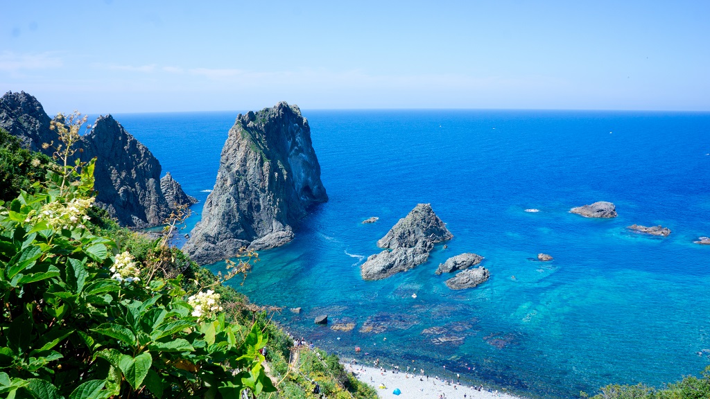
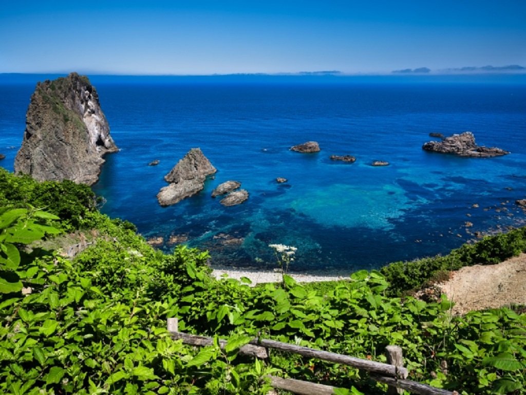
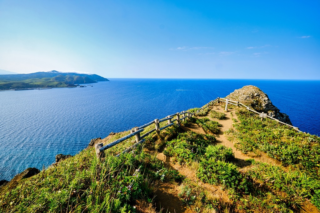
No.3 島武意海岸
積丹半島にある波打ち際まで下りられるスポットで、積丹ブルーと言われています青い海に屏風岩などの岩礁が浮かぶ絶景地です。
駐車場から展望台まですぐなのも嬉しいところで、海岸にも下りられます。15km先には絶景108で選ばせていただきました神威岬もあります。
但し、熊にはご注意を。
No.3 Shimamuikaigan
It is the superb view place where the reef of a perpendicular cliff and so on occurs to the blue sea said to be the Shiyakotan blueness with the spot that can get down to the shoreline that is in Shakotan-hanto.
It is possible to fall in the seashore, too, in a place with immediately being from a parking lot to an observatory to be glad about, too.
There is Kamuimisaki chosen at superb view 108, too, 15 km ahead.
Of, however, being careful of a bear.

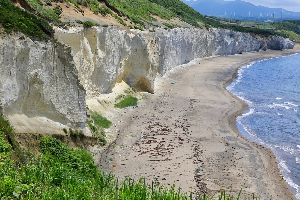
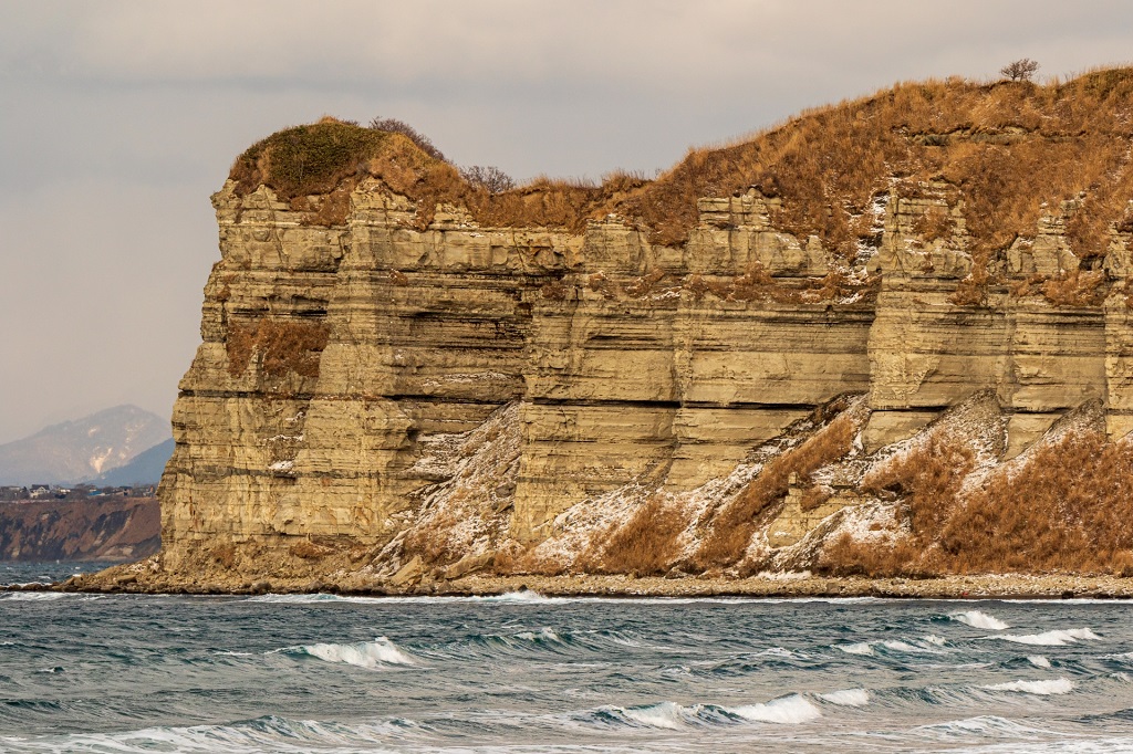
No.4 滝瀬海岸(シラフラ)
北海道の渡島半島の西側、国道229号線沿いにあります滝瀬海岸(シラフラ)。シラフラとはアイヌ語で白い傾斜地という意味です。白い石灰岩の約15mの崖が約500mに渡り続く秘景地です。
シラフラまでは徒歩10分ほど。道すぐに眺望地もあります。また、約400年前にニシン漁の運搬用に穴が掘削されたくぐり岩もあります。
No.4 Takisekaigan(shirahura)
Oshima Peninsula of Hokkaidou the west side, Takise seashore that are along a national road No. 229 line ( SHIRAFURA ).
SHIRAFURA is a meaning such as the white sloping ground in an Aino.
About 15 m of cliffs of a white limestone are 秘景地s that pass to about 500 m and continue.
As 10 minutes on foot until SHIRAFURA.
A road has a view place, too, immediately.
Also, there is the dive rock which a hole was excavated about 400 years before for herring fishing ‘s carriage with, too.

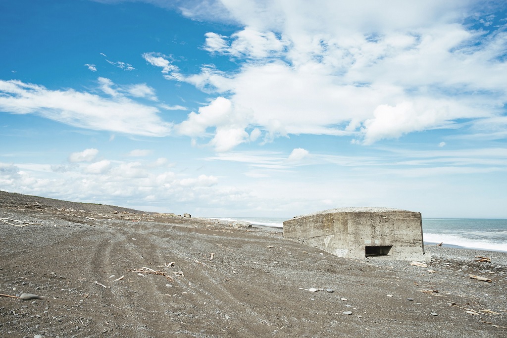
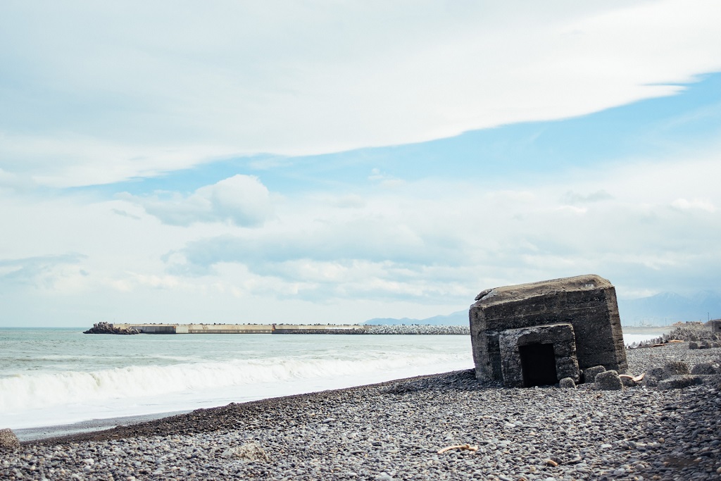
No.5 旭浜のトーチカ群
トーチカとは戦時中に使われました鉄筋コンクリート製の陣地のことです。ここ大樹町にある旭浜の海岸にあるほか、内陸部も含めますと大樹町には15基ものトーチカが確認されています。
昨今、崖下にある宙に浮くトーチカが発見されましたが、残念ながら崩落してしまいました。朽ち始めていますので、訪ねるならお早めに。
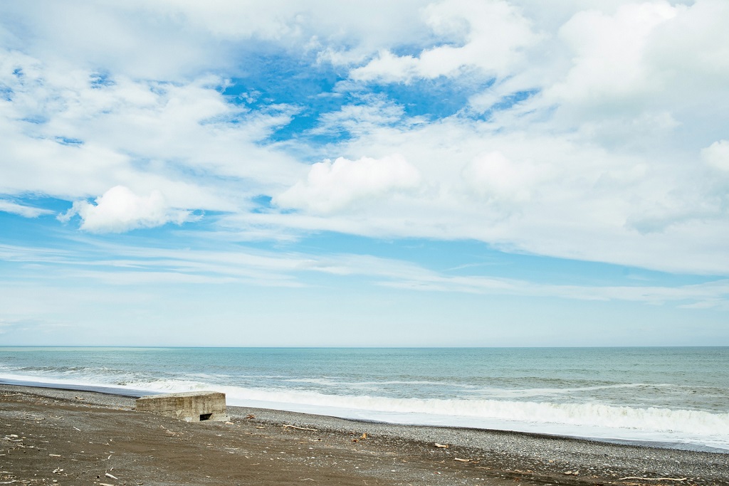
No.5 Pillbox group of Asahihama
A pillbox is the positional thing made of the ferroconcrete used during the wartime.
Here is in the seashore in Asahihama that is in Taiki-cho and also Taiki-cho confirms that 15 pillboxes include an inland area, too.
The pillbox pending that is in the foot of a cliff had been found these day but collapsed unfortunately.
To hasten if visiting because it is beginning to decay.
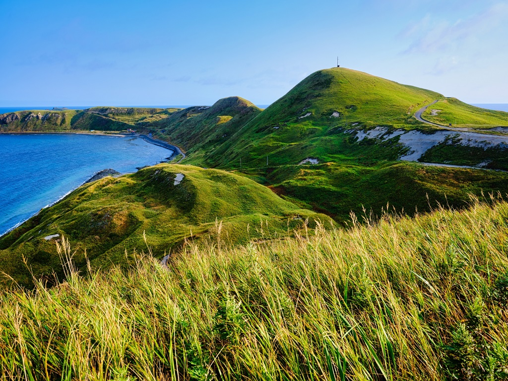
No.6 ゴロタ岬
絶景の宝庫の離島の礼文島。ゴロタ岬の展望台は、駐車場から25分ほど歩きますが、スコトン岬やゴロタ岬の絶景が望める、まさに秘景の地です。
また、礼文島には駐車場の近くにありアクセスの良い澄海岬や、利尻富士の遠望を望めます桃岩展望台など多くの絶景展望台があります。
是非、一度は訪ねてみたい島です。
No.6 Gorota cape
Rebun-to in a remote island in a treasure house in a superb view.
It does of wanting a superb view in Cape Sukoton and GOROTA cape possibly though it walks in an observatory in a GOROTA cape from a parking lot as much as 25 minutes indeed a place in secret view.
Also, there are many superb view observatories such as an accessing good Sukai cape and Momoiwa observatory that can want the distant view of Rishirifuji, being near a parking lot, in Rebun-to.
1 degree is the island which we want to try to call on by all means.
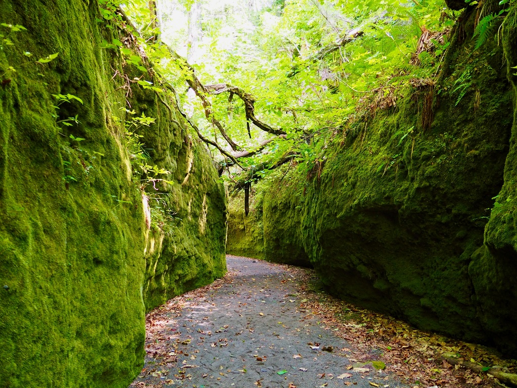
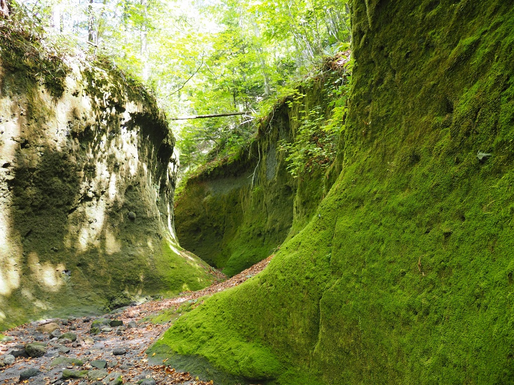
No.7 苔の回廊
支笏湖のそばにあります苔の回廊は、枯れた沢に残った緑の苔に囲まれました道が続く、とても幻想的な場所です。
ネイチャーセンターから苔の洞門までは約750メートルで、高さは約10m、80種以上のコケが密生しています。
駐車スペースから徒歩20分ほどで苔の回廊の入り口に到着。さらに20分ほど歩くピストン路になります。但し、自然災害などにより閉鎖中になっている場合もありますので、事前にご確認を。有名な苔の樽前ガローとは樽前山を挟んで反対側になります。なお、熊にご注意を。
no.7 Corridor of the lichen
The corridor of the lichen that is near Shikotsu-ko Lake is the very fantastic place where the road surrounded with the green lichen left in a dead marsh continues.
Even the cave entrance of the lichen is about 750 meters from a nature center, and about the height, about 10 m, equal to or more than 80 kinds of moss is thick.
It arrives at an entrance in the corridor of the lichen from a parking space as much as 20 minutes on foot.
Moreover, it becomes a piston road to walk as much as 20 minutes.
Do, however, confirming beforehand because it sometimes comes to close by a natural disaster and so on.
With Tarumae Garraud of the famous lichen, it becomes across Tarumaezan on the opposite side.
Of, still more, being careful of a bear.

No.8 黄金山
石狩市にあり、浜益富士、黄金富士とも呼ばれています、円錐形の特異な形をした標高739mの山です。山頂までは片道約2時間の登山になります。暑寒別天売焼尻国定公園内にあり、国名勝にも選ばれています。酷道451号線からその遠望を望むことができます。
No.8 Koganeyama
It is the mountain of 739 m of altitudes that were in Ishikari city and that have the shape with the cone peculiar Hamamasu Fuji, both both whose golden Fuji is called.
It becomes the mountain climbing of about 2 hours of an one way until a mountaintop.
It is in a Shokanbetsu-teuri-yagishiri quasi national park and is chosen as the win of a name of the country, too.
It is possible to want that distant view from a Route 451.
No.9 あんない展望公園
積丹半島の海岸線を走ります国道229号線沿いにある展望公園です。本来であれば、ここからそのごく一部の遠望が望めます異世界感を感じられるジュウボウ岬/西の河原を挙げたいところですが、駐車場より整備されていない道なき道を40分も歩くのと、熊も出るため、同署の遠望が望めます展望公園を選出しました。
窓岩の眺望も望めます。
No.9 Annai view park
It is the view park that is along the national road No. 229 line that runs in a coastline in Shakotan-hanto.
It elected the view park where it is possible to want same station ‘s viewing from a distance to be the place where we want to raise the shore of the river in a JUUBOU cape / west which the different world sense of its being possible to want those a small percentage of distant views from here is felt to if original but for a bear, too, to appear with one that walks for 40 minutes on the road which a road not to be prepared for from a parking lot isn’t in.
It is possible to want the view of Madoiwa, too.
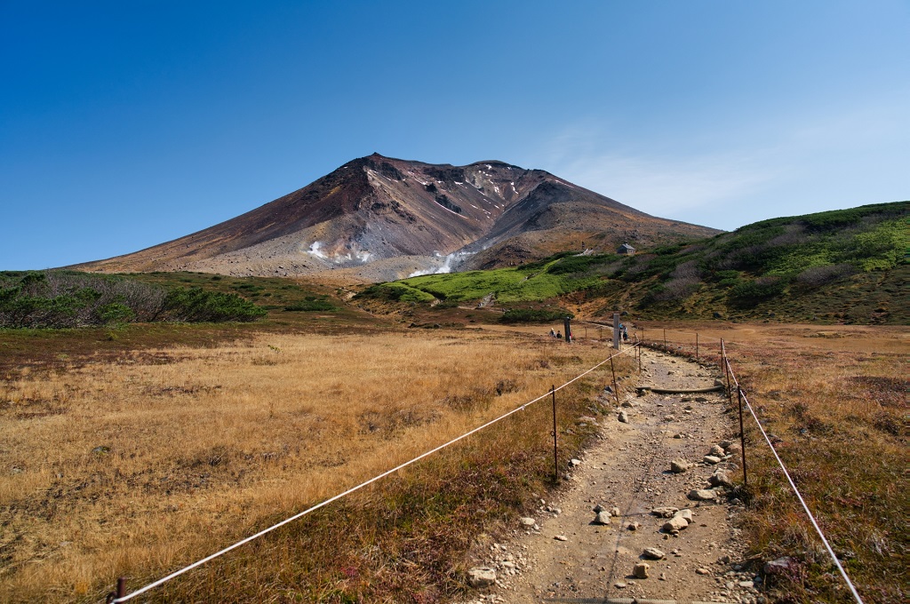
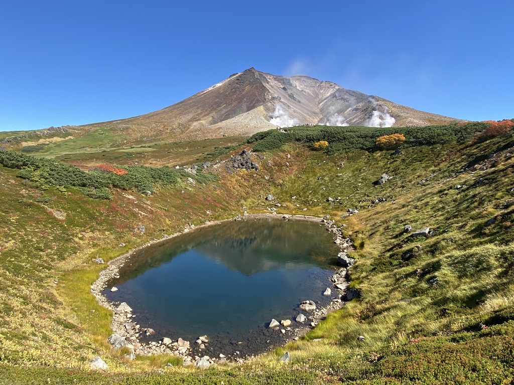
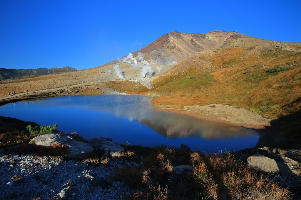
No.10 旭岳の展望台群
標高2,291mの北海道の最高峰の旭岳。旭川市街から西に45km、約1時間で旭岳ロープウェイ山麓駅に着きます。ロープワエイで10分(2,200円)でロープウェイ姿見駅に到着します。
姿見駅から近くの第1展望台から、一番遠い第5展望台、姿見展望台まで歩いても20分ほど。姿見の池や擂鉢池越しの旭岳の絶景を望めます。

No.10 Observatory group of Asahidake
Asahidake of the highest peak of Hokkaidou of 2,291 m of altitudes.
It arrives at the station of the Asahidake ropeway foot of a mountain west from an Asahikawa city in 45 km, about 1 hour.
It arrives at a ropeway full length mirror station in ROPUWAEI in 10 minutes ( 2,200 yen ).
Even if it walks to 5th observatory, full length mirror observatory the farthest from a full length mirror station from 1st observatory near, as 20 minutes.
It is possible to want a superb view in Asahidake over the pond and earthenware mortar pond of a full length mirror.

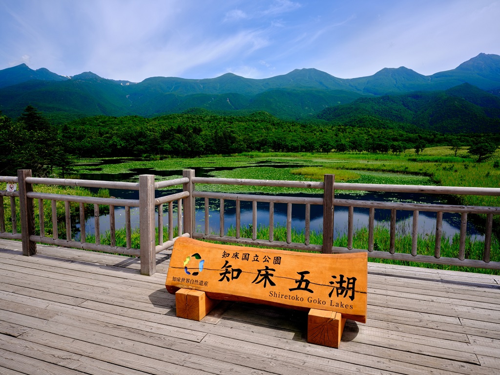
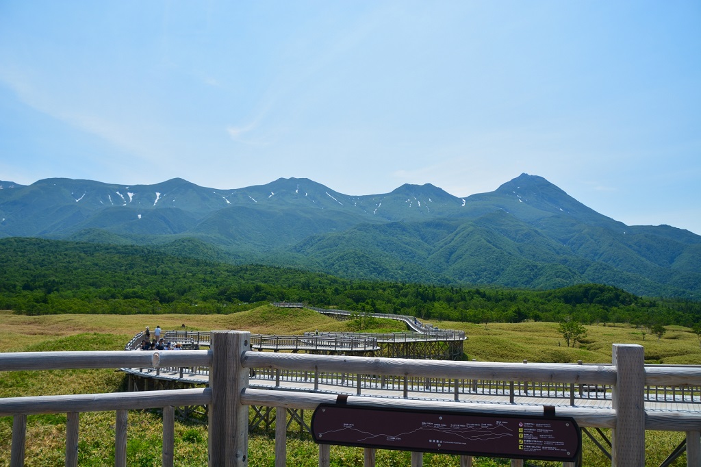
No.11 知床五湖の展望台群
秘景というよりは著名な景勝地ではありますが、バイクで気持ちよく知床横断道路を走っていますと、知床峠で止まっても知床五湖はスルーされながちなため、今回、選出いたしました。
知床五湖は湯の滝で有名なカムイワッカの滝へ行く道中にあり、オコツク展望台ほか、いくつかの展望台があり、終着の湖畔展望台までは駐車場から徒歩15分ほどです。
なお、遊歩道の近くには熊よけの電線が張られているくらいのヒグマの生息地のため、観光ルート以外は行かないようにご注意を。

No.11 Observatory group of 5 lakes of Shiretoko
Rather than secret view, it was a famous scenic area but even if it stopped in a Shiretoko mountain pass, because through SARENA was CHI, 5 lakes of Shiretoko were elected this time when running pleasantly by a motorcycle in a Shiretoko crossing road.
There are 5 lakes of Shiretoko to Michinaka who goes to the fall of KAMUIWAKKA famous for the fall of the hot water, and there are some observatories in a OKOTSUKU observatory and so on, and even a Kohan observatory in a terminal point is as much as 15 minutes on foot from a parking lot.
Of, still more, being careful not to go for the habitat of a brown bear as much as the electric wire of 熊よけ being laid near in an esplanade except a scenic route.
No.12 館の岬
北海道の南部にあります渡島半島の西岸、乙部町の海岸線沿いにある、白と黒の岩層が連なる高さ50mの白亜の岸壁です。
国道沿いのビューポイントからその優美な景観を望むことができます。東洋のキャニオンとも呼ばれ、江戸時代の悲恋の物語も語り継がれています。

No.12 Tatenosaki
It is the quay of 50 m of chalks in height that the white and black terrane that is along the west coast of Hokkaidou in Oshima Peninsula that is in the southern part, coastline in Otobe-cho affects.
It is possible to want that elegant view from a scenic area along a national road.
It is called an Oriental canyon, too, and the story of the tragic love at the Edo period, too, is handed down.
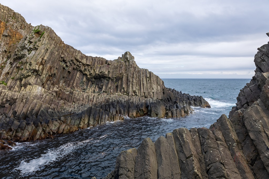
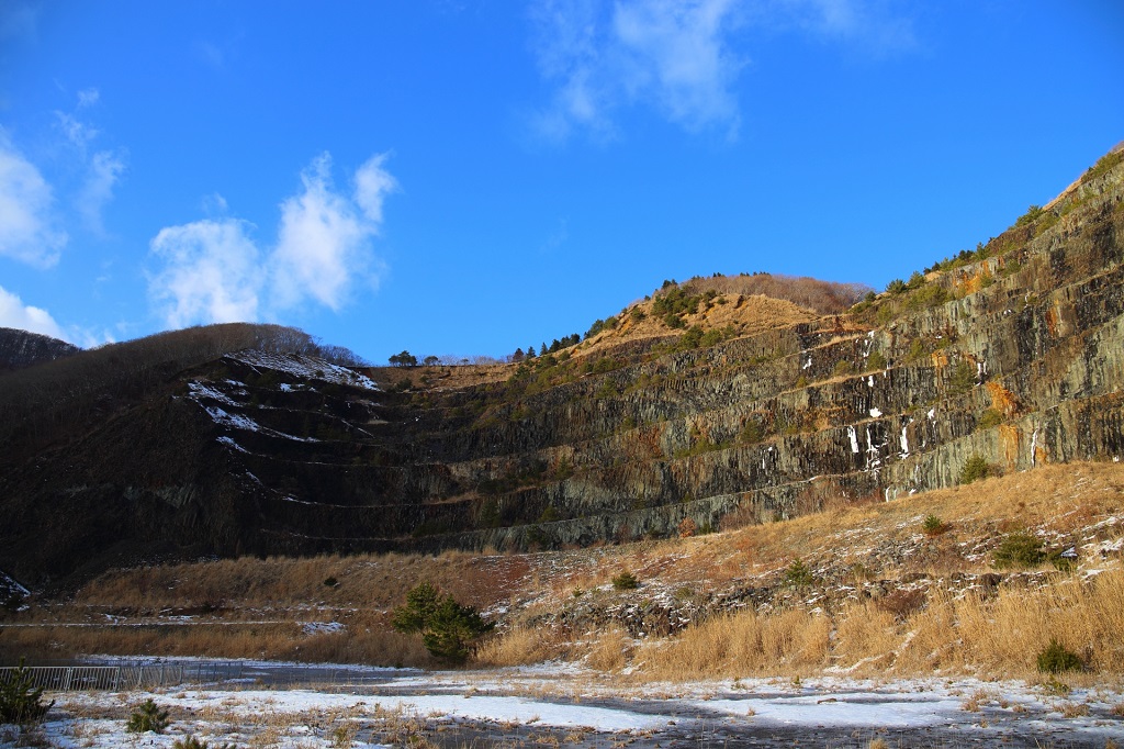
No.13 日浦海岸/道南金剛
函館市街から海沿いに東に45km進み、日浦漁港方面へと曲がり最奥地の日浦岬灯台のあたりまで行きますと、むき出しの柱状節理の日浦海岸の奇景を望むことができます。
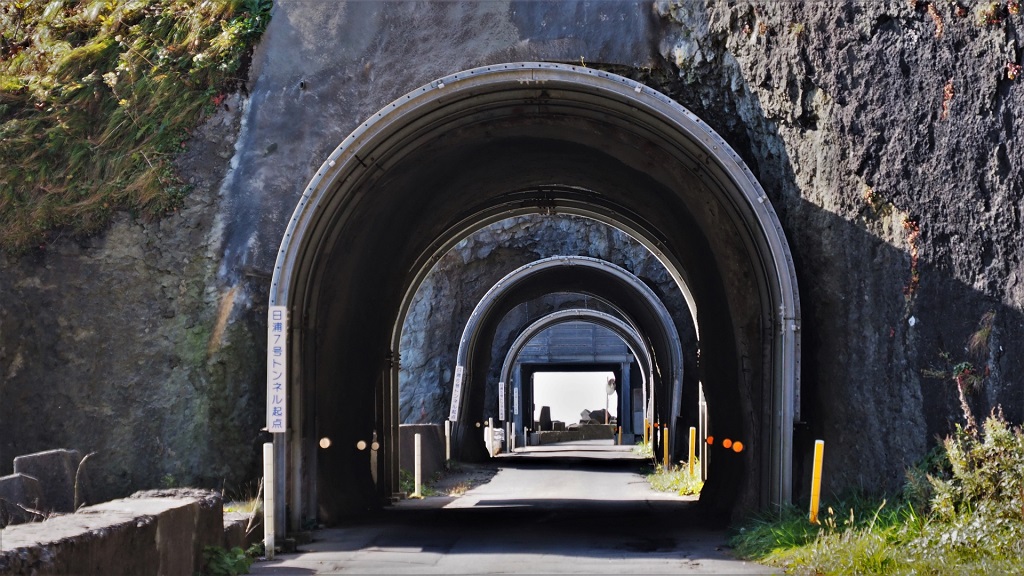
その後、海沿いの県道に1929年に開通しました7つの連続する素掘りトンネルを抜けますと、山側から道に迫る圧巻の柱状節理の道南金剛を見ることができます。
道南金剛は、かつては採石場として使われていたところで、奇勝感はもちろんのこと圧倒される景観を楽しめます。
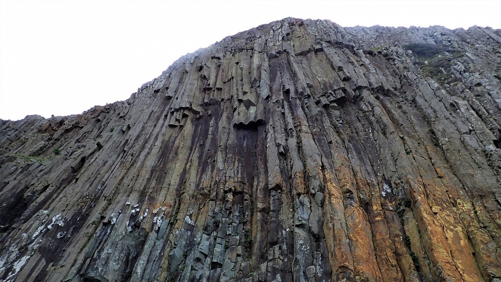
No.13 Hiurakaigan/donankongo
Hiura of an open columnar-joint can want a seashore extraordinary view when moving ahead west from a Hakodate city along the sea for 45 km and turning to a Hiura fishing port area and going around a Hiuramisaki lighthouse in most outback.
After that, it is possible to see Donan Kongou of the columnar-joint of the highlights that approach a road from a mountainside when going through the element digging tunnel that seven reopened in a prefectural highway along the sea in 1929 continue.
Donan Kongou has been just used formerly as a quarry and can enjoy the sense of a beauty spot and also overwhelmed view.
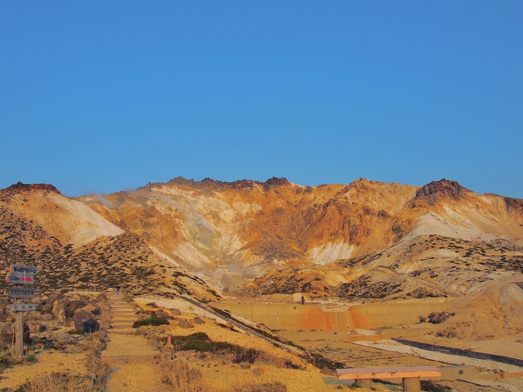
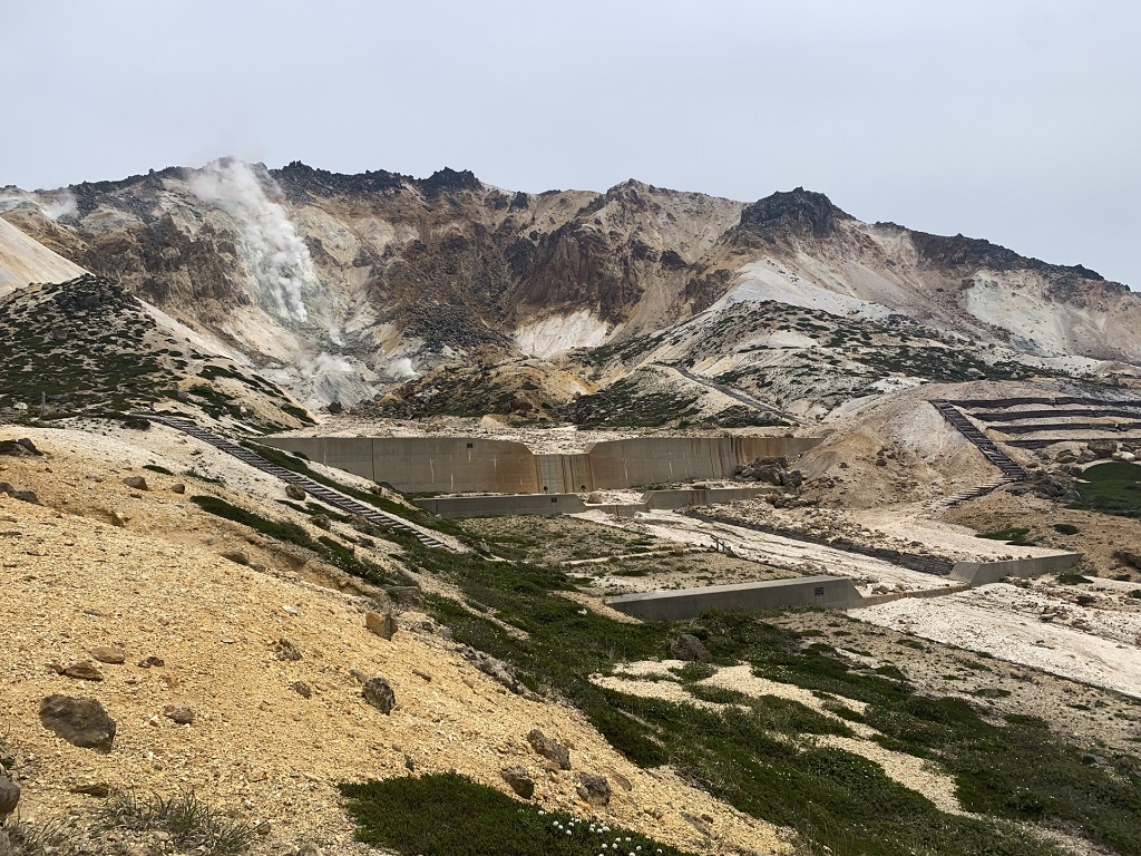
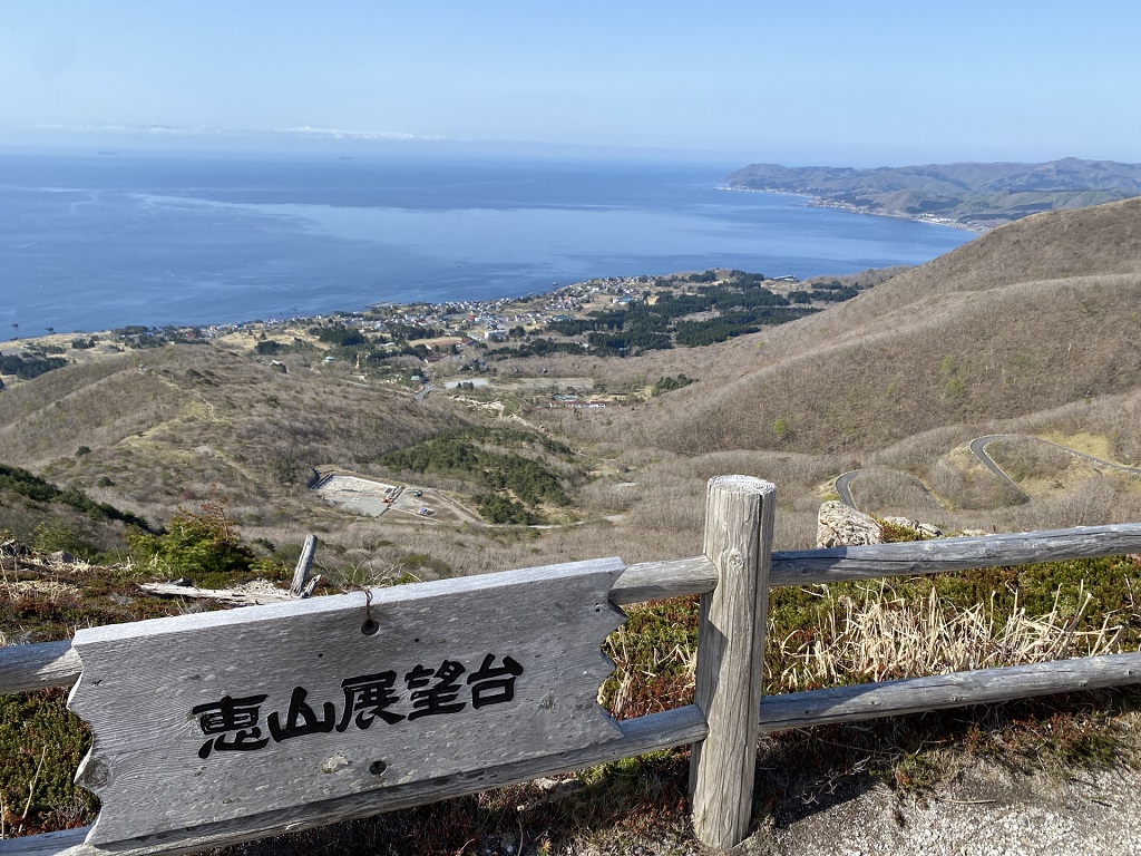
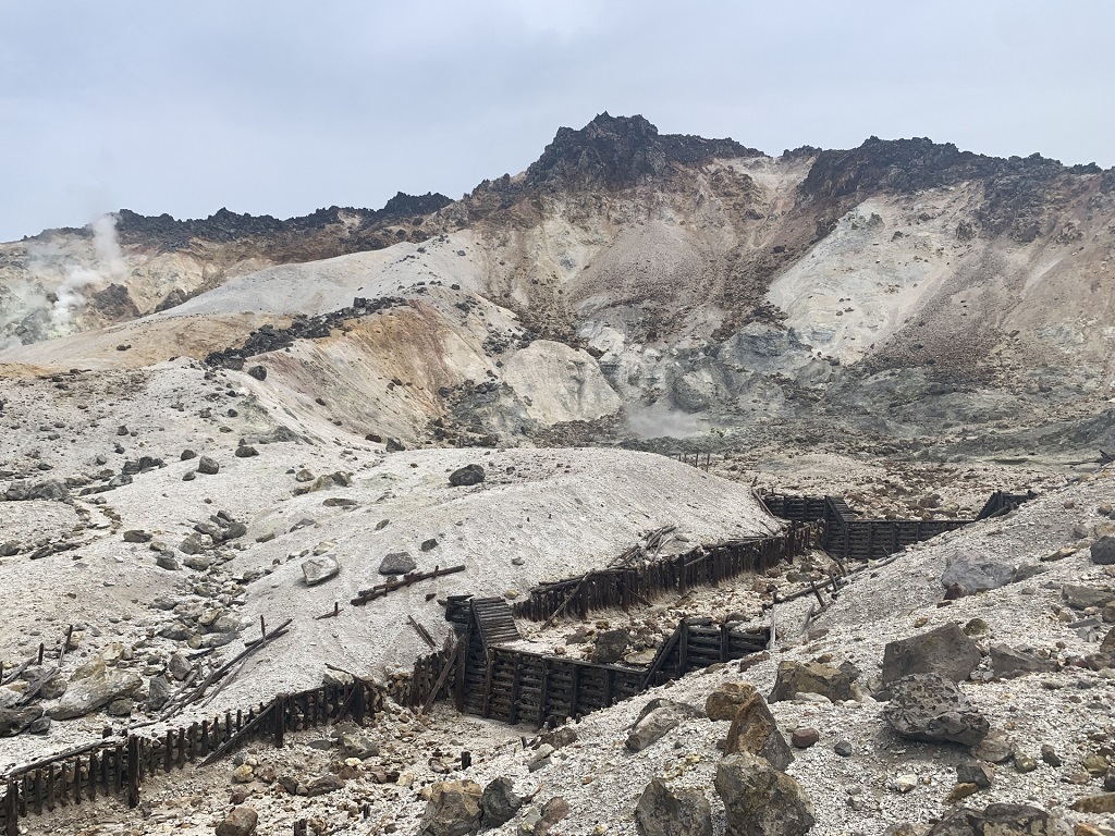
No.14 恵山
函館市街から東へ50kmほど走った渡島半島の南東部にあります標高618mの活火山で、今も噴気をあげています。
標高300mのところにあります火口原駐車場まではバイクで行くことができます。駐車場から噴気があがる荒涼とした景観を見つつ、40分ほど歩きますと恵山展望台に到着し、眼下に海峡が、そして、青森の遠望を望むことができます。
但し、熊がよく見かけられる場所で、且つ足元も悪い場所もありますので、熊除け鈴は必携で、そして自己責任で。展望台まではちょっと…という方も、火口原駐車場からでも恵山の景観を望むことができます。
また、6月中旬~下旬にかけて、恵山ツツジを楽しむことができます。
No.14 Esan
Still it improves the discharge in the active volcano of 618 m of altitudes that are in the southeastern area in Oshima Peninsula that ran from a Hakodate City town to the east as much as 50 km.
It is possible to go to the crater basin parking lot that is at 300 m of altitudes by a motorcycle.
It arrives at an Esan observatory when walking as much as 40 minutes while seeing the rough view which the discharge rises from a parking lot to, and a strait can, then, want Aomori ‘s viewing from a distance under the eyes.
At the place where a bear is come across well, by, however, moreover, a bear exclusion bell being indispensable because there are both a footing and bad place, by then, the self-responsibility.
Until an observatory, a person such as…, too, can want the view of Esan even from a crater basin parking lot a little.
Also, it is possible to enjoy an Esan azalea to the middle of June – last ten days.
")


")


